Service Description:
Electric Vehicle Charging Stations
The SACOG planning area has 721 public ev charging stations according to the US Department of Energy; as of June 6th 2023.
https://afdc.energy.gov/fuels/electricity_stations.html
This data includes Level1, 2, DC Fast, and Legacy charger types.
This data includes all connectors J1772, CCS, CHAdeMO, and Tesla.
This data includes all available charging networks within the SACOG planning area.
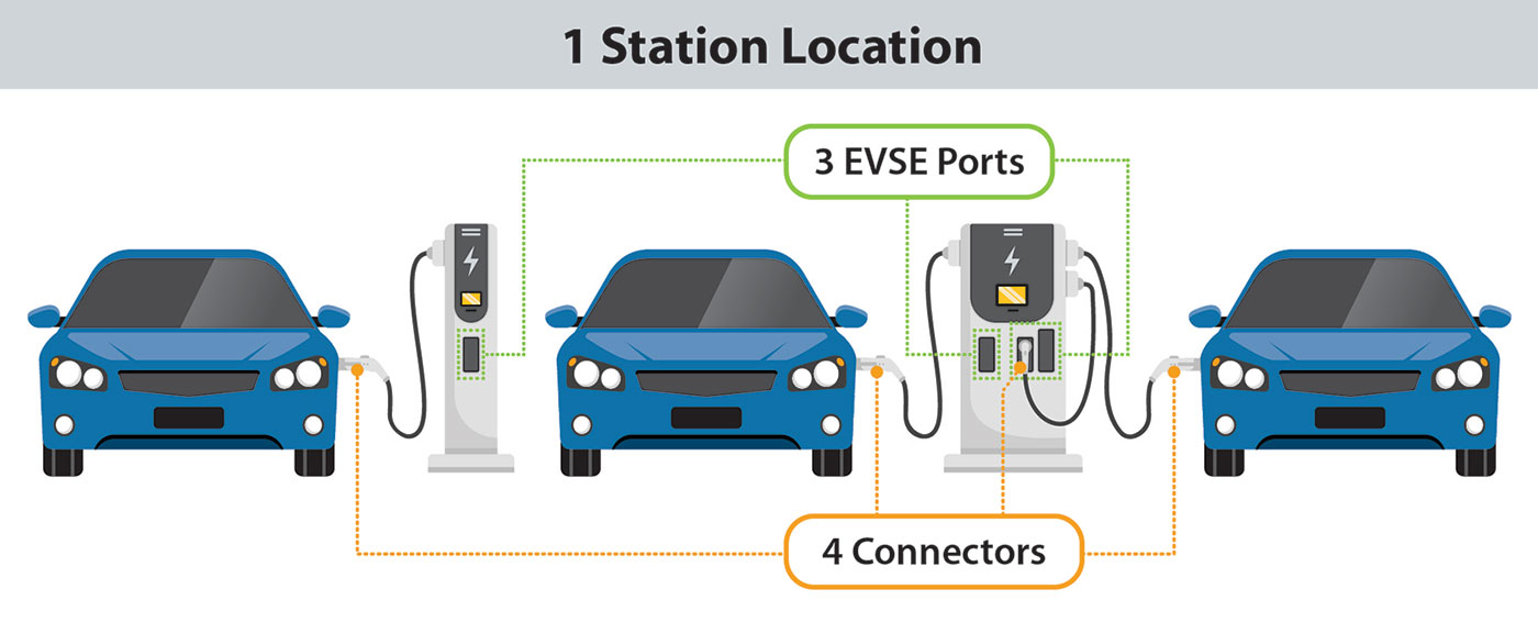
Charging Infrastructure Terminology
The Alternative Fueling Station Locator uses the following charging infrastructure definitions:
Station Location: A station location is a site with one or more EVSE ports at the same address. Examples include a parking garage or a mall parking lot.
EVSE Port: An EVSE port provides power to charge only one vehicle at a time even though it may have multiple connectors. The unit that houses EVSE ports is sometimes called a charging post, which can have one or more EVSE ports.
Connector: A connector is what is plugged into a vehicle to charge it. Multiple connectors and connector types (such as CHAdeMO and CCS) can be available on one EVSE port, but only one vehicle will charge at a time. Connectors are sometimes called plugs.
Map Name: EV Chargers
Legend
All Layers and Tables
Dynamic Legend
Dynamic All Layers
Layers: Description:
Electric Vehicle Charging Stations
The SACOG planning area has 721 public ev charging stations according to the US Department of Energy; as of June 6th 2023.
https://afdc.energy.gov/fuels/electricity_stations.html
This data includes Level1, 2, DC Fast, and Legacy charger types.
This data includes all connectors J1772, CCS, CHAdeMO, and Tesla.
This data includes all available charging networks within the SACOG planning area.
Charging Infrastructure Terminology
The Alternative Fueling Station Locator uses the following charging infrastructure definitions:
Station Location: A station location is a site with one or more EVSE ports at the same address. Examples include a parking garage or a mall parking lot.
EVSE Port: An EVSE port provides power to charge only one vehicle at a time even though it may have multiple connectors. The unit that houses EVSE ports is sometimes called a charging post, which can have one or more EVSE ports.
Connector: A connector is what is plugged into a vehicle to charge it. Multiple connectors and connector types (such as CHAdeMO and CCS) can be available on one EVSE port, but only one vehicle will charge at a time. Connectors are sometimes called plugs.
Service Item Id: 24e1284a1e164766aace3f11a1fdaf4d
Copyright Text: US Department of Energy SACOG
Spatial Reference: 102642 (2226)
Single Fused Map Cache: false
Initial Extent:
-
XMin: 6644219.057084895
YMin: 1869567.6162978369
XMax: 6849156.14019525
YMax: 2068448.6390325897
Spatial Reference: 102642 (2226)
-
XMin: 6520725.499375001
YMin: 1858204.5887500048
XMax: 7147426.693749994
YMax: 2241703.2275000066
Spatial Reference: 102642 (2226)
Supported Image Format Types: PNG32,PNG24,PNG,JPG,DIB,TIFF,EMF,PS,PDF,GIF,SVG,SVGZ,BMP
Document Info:
-
Title: M:\ArcPro_cmcclain\MyProjectCensus.aprx
Author:
Comments:
Subject:
Category:
Keywords: EV,Electric,Charging,Charger,Station,Public,Transportation
AntialiasingMode: Fast
TextAntialiasingMode: Force
MaxRecordCount: 2000
MaxImageHeight: 4096
MaxImageWidth: 4096
Supported Query Formats: JSON, geoJSON, PBF
Supports Query Data Elements: true
Min Scale: 0
Max Scale: 0
Supports Datum Transformation: true
Child Resources: Info Dynamic Layer
Supported Operations: Export Map Identify QueryLegends QueryDomains Find Return Updates